Artefacts galore!

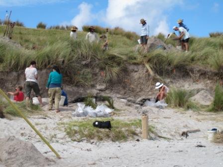
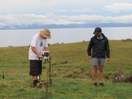
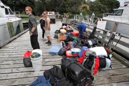
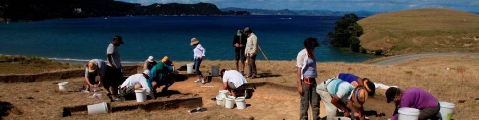
Today we opened a test pit (a 1x1m hole) in a new excavation area. It was a place that was selected near the beach for its unnatural flat plateau, and was run with the geophysical survey a couple of days ago. There were some places on the plateau that came out as anomalous on the survey, and our new test pit was one of them.


We began by finding the interesting point on the plateau, and putting pegs in the four corners of our test unit. Rebecca was on the dig team with me, and together we de-turfed the square (digging out all the grass!) and began digging. We dug slowly, making sure that if there was anything interesting in the excavation that we didn’t break it. It turned out that today was our lucky day, and we found heaps of artefacts. Right after the grass came off, the floodgates opened, and we found big basalt flakes, obsidian flakes and chert. We had barely been digging for 10 minutes before we had to stop and catalogue all of our finds. The theodolite team (the ones who survey and map out the area) came over and used their technology to map where the artefacts were found in the hole. This made our progress slow, since they had to come running over so often!


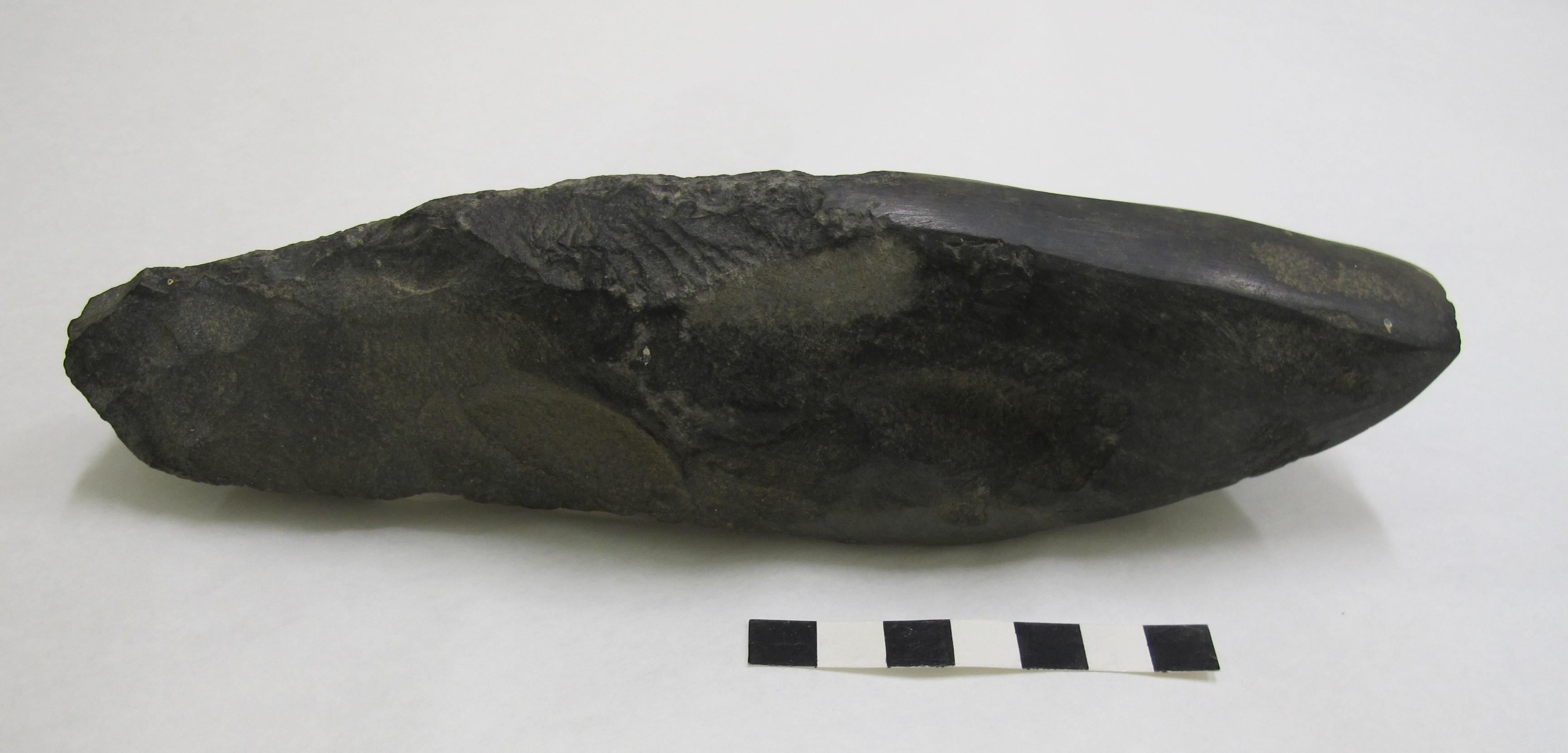
Layer 1 was relatively small, and only went 10cm deep. Even so, we found so many great artefacts it took all morning to get down that far. Overall we had some amazing obsidian, chert and basalt, as well as shell and charcoal. By then it was lunch time and we went in to eat.


The afternoon weather was tough as it rained quite a bit, and quite often. Thankfully we put up canopies over the excavation areas, and we were sheltered. From then onwards we made rapid progress down through layer 2, since it didn’t have many artefacts and the sand was much easier to dig through. There were some interesting finds anyway, and by the end of the day we had a firescoop, a post hole and an interesting large rock. The firescoop was shallow in the second layer, and is where charcoal after an ancient fire was swept after it had been put out. It came out as a lense of black charcoal in the orange-brown sand. The large rock was found mid-way down the second layer and had a flat base and a rounded top. It was right in the middle of the pit and for a time we had to excavate around it. The tutor, Alex, examined it for rock art or special significance, but couldn’t find any. Finally the post hole was found late in the day, and took us all by surprise. It was where an ancient post was placed in the ground and was later in-filled with different dirt than what would naturally be there. As Rebecca and I were smoothing the edges of the wall of the hole, Rebecca said: “Hey Alex, I think that’s a post hole!” … and we all came running. It was a genuine post hole, and only the second one of the whole trip. We were very happy and quickly took photos. We then dug down the hole removing the fill with a spoon until we found the bottom of it. It was a great end of the day. Hopefully tomorrow will be equally as exciting.

– Laura

Posted in Uncategorized | Comments Off on Artefacts galore!

A change of scene

Work on the dune face, and on the flat behind

The garden site excavation has finished and Thegn has gone back to Auckland. Simon Holdaway has arrived to direct excavations in the second week. Simon’s interests are in lithics (stone tools) and formation process (how the tools got to where they are now). We have started work on the dunes in the middle of the island near where we are staying. During a severe storm in 2007 the dunes were cut back exposing a black cultural layer and shell midden. We have relocated this deposit using a GPS, and cleaned up the slumped sand to expose the vertical face again. The intention is to draw the stratigraphy or layers to scale and to take samples of shell and charcoal for identification of wood used to fuel the fires.

Other teams are working further back in the dunes looking at the geomorphology of the dunes and the archaeological or cultural layers relative to natural layers in the dunes by coring metres down into the sand and recording the changes in sand colour. Another team is working on the top of the dune where stone flakes were exposed in an erosion area. Work will progress in each of these areas over the next week. Support teams using geophysical equipment identify anomalies under the surface and potential areas for excavation, and a survey team using a total station records finds and excavation areas precisely.

The different teams are working in different conditions. It has been sunny for the last few days with a breeze from the east. This is perfect for those teams working on the top of the dune but those on the west side of the dune, below a 3 m high scarp, are sweltering in the still hot conditions. Add a lot of physical work of shovelling sand into the mix and some teams finish the day feeling exhausted.

We are always under pressure to recover as much information as possible and it is more difficult to return to the island to take some measurements or check a layer so we are trying to get as much work done as possible before this field season ends on Sunday. We are working longer days – 7.30 to 5, with ¾ hour for lunch and no formal stop for morning and afternoon break. It is interesting to see the students, who have not excavated before, being so enthusiastic about their work and having no complaints about the long days or heat.

Children on Great Mercury Island helping the archaeologists sieve

The team on the beach has cleaned up the slumped dune face to a straight surface and have sieved the sand residue from the cultural layers being excavated to recover any flakes which escaped the sharp eyes of the excavator. On Monday we had a visit from the two resident children doing correspondence school. They were intrigued by our activities and had a go at sieving.

In preparation for the work on the dune face being completed, a team started excavating a large square behind. After the dune section was recorded and photographed, the awesome diggers in the square behind started shovelling out the sterile sand overlying the cultural layer to connect up the two areas. Many cubic metres of sand were shovelled today, and on the last day all the sand has to be shovelled back into the excavated squares. In the meantime, the next three days of excavating will prove exciting as more cultural layers are uncovered.

– Louise

Posted in Uncategorized | Comments Off on A change of scene

Pa Adventure

Students survey gardening areas close to Tamawera Pa

After six days of digging we finally got our first day off, with a fantastic sleep in till 7:30am! Our great Pa adventure started at 10 am where we were driven to the outskirts of Tamawera Pa. While waiting for the second load of people we practiced rock art survey and some cow dialect in order to connect with the landscape. Our gentle walk started with a near vertical hike up to the garden complexes of the Pa.  Rock alignments and terraces covered the whole area, stretching down to the other side of the hill. Some amazing observation skills noticed a water worn rock out of context, which was explained as a possible religious shrine such as the ones found on Hawaii.

Tamawera Pa

After lunch, and skimming stones on the beach, a few brave souls started the next climb to the top of the Pa. Without a clear path scaling the Pa face was a challenge.  Avoiding stone face terraces, gorse and sheep poo added to the complication. However the view at the top was well worth it! Sights extending from Whitianga to Little Barrier Island set the scene and looking at the scale of the site put into perspective just how populated the island must have been. It has made the work we have been doing seem a lot bigger than previously thought.

The panoramic views from the Pa were amazing and we took the opportunity to stage a few amateur photo shoots.  We took our time exploring the area; drinking up the history and listening to our supervisors express their thoughts and ideas on the area. The size of cultural features such as storage pits, possible housing platforms and the stone face terraces lead into discussions surrounding hypotheses of subsistence, warfare and general living of Maori in pre-European times.  All in all an amazing learning experience.

After a good five hours of walking, learning and climbing we missioned back to enjoy wonderfully refreshing swim in blue crystal waters on a beach of white sands. We finished the day off with an amazing roast dinner and mouth-watering apple crumble. With a good night sleep we should be well prepared to get back into the swing of things bright and early Monday morning.

– Rebecca and Francesca


Posted in Uncategorized | Comments Off on Pa Adventure

Digging

After several days of excavation, I can confidently say that I am enjoying myself!

Starting out my first day of excavations, we opened a 1×1 metre test pit across a section of the stone alignments, in the garden zone. After being told several times, to not be so precious with my use of the trowel and to just get stuck in and whack out the top soil, I found that my afternoon went quite quickly as we were soon at the bottom of the test pit.  Moving on to a new test pit on Day 2 revealed new layers and levels within the gardening zone, and a different use within the same gardening area.

After finishing the excavations in the garden area, I have moved onto stratigraphy drawings. Drawing the stratigraphy is an important part in cataloguing the archaeological record where we transfer the visible layers of the test pit to a scale version on paper. I am enjoying the drawing, even after finding out at 5 minutes until the end of the day on site, that my third drawing was not quite to scale…just a slight learning curve. But, it is very important to note that the use of consistent scale is key!

Through rain and shine we have worked on this beautiful island. Uncovering lots of new layers and levels in the garden zone and filled out so many forms…which we hope the students on registry can interpret!

My new clothes no longer look new. They are covered in mud and I think they are set to stay this way. I am not phased anymore at the prospect of getting stuck in and getting covered in mud- in fact, I think I quite like it J


– Krystle

Posted in Uncategorized | Comments Off on Digging

Day 3

Garden Site

Excavations are well underway. Today was fine and very warm, and an improvement on the steady rain yesterday. Although we had shelters over the excavation areas on Day 2 the soil was very wet and water was seeping through the uphill edge of each square. Work had to stop on the 3D scanning of the garden site and surveying using the total station.

We are excavating a site with stone alignments running down a west facing slope. The stones, which were probably levered out of the gardens between the stone rows, acted as plot boundaries. Kumara were probably grown in the gardens but this is subject to confirmation after analysis of soil samples. Each cultigen plant (kumara, taro, yam) leaves distinctive microfossils in the soil.

Excavation, note the stone rows running down the slope

Sieving soil

Thegn Ladefoged, who has carried out research on gardens in Hawaii and on Rapanui (Easter Island), is directing the garden excavation. Excavation trenches have been placed across stone rows to look at the soil depth and texture on either side of the stones, and also to investigate whether the stones were sitting on the subsoil below the garden, or had garden soil underneath them. We also excavated other trenches between the rows to look at the soils. On Day 2 a stone alignment set firmly into the ground surface was excavated and the stones were resting on the underlying clay. On Day 3 we commenced excavating on two alignments which were at a slightly different angle on the slope to the other rows. These were found to be seated within the garden soil, suggesting they were placed there after gardening commenced. There is also a flat area above the garden which might have been an occupation site, and some test pits are also being placed on this area.

Excavation

After de-turfing off the topsoil with spades, we are hand excavating the garden soil, sieving the soil to look for any stone flakes or unusual materials which wouldn’t be found there naturally. Charcoal is extracted from a sample of soil to indicate what was growing there prior to when the gardens were used, but also what was growing between uses of the gardens.

Recording of archaeological excavations is essential as it is from the written and photographic record that the report is written. Each layer is described on a form and the surface of each layer photographed. The surveyors then come along with the total station and take levels in each corner. These heights are recorded as height above sea level. The forms are comprehensive and we are still in learning mode but can appreciate that the database, in which all information is entered, must have consistently collected information to be effective.

Checking the map made using the total station to make sure all rocks are recorded

Each evening, after work ends, we have a team meeting where each excavation group shares what they were doing with the rest of the crew. An archaeologist or senior student will then give a short talk about a research project underway or recently completed. As this is a field school to teach students about archaeology, they have a full on day in excavation and other activities then have to write up a field journal each evening which contributes to their final mark in the paper. After dinner, the staff and assigned students work late into the evening checking and entering information captured on the record sheets into the database.


– Joe

Posted in Uncategorized | Comments Off on Day 3

Geophysics

The geophysics team studied a 20m2 area on a terrace above the rock gardens under excavation. Geophysics is a non-intrusive survey technique that allows us to have a picture of what is underneath the ground without having to dig it up. This allows us to target good spots for later excavation. We began by marking out a square 20m2 grid aligned to magnetic north. Following this we used a fluxgate gradiometer to study the resistivity of the ground. This testing shows what may be concentrations of water in infilled storage pits (low resistance) or rock alignments (high resistance) beneath the topsoil. We found a line of high resistance along the western edge of the terrace, suggesting a possible rock wall. In the centre of our 20m2 there is a 2nd terrace level which shows a lower resistivity, suggesting different soils between the two levels. After the resistivity testing we used a magnetometer to study the magnetism of the ground. High magnetism may mean remnants of burning are below the surface, such as a hearth, while lower magnetic readings suggest undisturbed soil. Our results show a slow gradation of magnetism below the surface, reflecting the contour of the slope. There are some anomalies, though are rather small, that may require further investigation. We are about to extend the area 20m southward to further study the difference between the two terrace levels, where there is a sharper ridgeline.


– Zac


Example of first resistivity survey – dark areas equal low resistivity, light areas equal high resistivity.

Posted in Uncategorized | Comments Off on Geophysics

Day 1

Students and staff awoke to clear skies and the promise of a good days work ahead. Setup on site began early with the GPS base station being positioned and theodolite stations setup, ready for a day of garden and trench survey. It wasn’t long before work became rocky, both in a literal and metaphoric sense – with the total station set for recording stone alignments refusing to close the polygon shapes, creating an intricate beeline patterning across the digital landscape. Several minutes of intense button pushing ensued to no avail, this was now a job for post-processing. Further technical issues emerged throughout the day, but work progressed well despite this, ending with the newly deturfed levels being shot in, a perimeter survey of the garden completed and a large amount of the garden rocks mapped. Despite several periods of extended down time during technical difficulties, both Jono and Francesca, the two field-school students assigned to survey for today, were keen and learned the operation of the machines quickly under difficult circumstances.

Once back at the house post-processing began in earnest, tidying the somewhat problematic data collected during the day. With the help of Jono the processing was completed in 4 hours and a plan view map of the garden was generated for further detailed mapping in the days to come.

Lets hope this… “rocky work” … goes smoother tomorrow!

xoxo GIS GIRLS (Sam & Tara)

Posted in Uncategorized | Comments Off on Day 1

Arrival – The Student Perspective

While booking a bus for 7.50am seems like a good idea a month ahead of time, it was not looked upon favourably once the first alarms were set to organise waking in time for it. Departing from Sky city bus station for Whitianga on Sunday was the first chance a small cluster of students, myself included, had to marvel at how this Field School had ‘snuck up’ on us.

The talks and warnings about ‘definitely bringing raincoats’ were well placed for those of us who did not know what to expect in regards to our first Field School experience. Rain was spoken of but pushed to the back of minds as something to be pleased that it wasn’t happening. Famous last words.

I cannot recall exactly when the drizzle began in Whitianga but definitely before we arrived at our backpacker accommodation. There was nothing to fear, however, as we had been well warned, as soon there were raincoats aplenty. After our respective dinners, and a few chance encounters with Alex (our tutor), at various stages of our night, we settled in for cards and a beer –in true Archaeology style!

We awoke to rain, which seemed to get worse each time we announced, “It couldn’t possibly get worse than this”, but we wrapped our clothes in plastic bags and made our way to the marina where we were to meet for the morning. Loading the boat was definitely made faster by an ample supply of eager students ready to follow the ‘if we are working, you are working’ to a tee. The men and staff were sent off to unload on the other side for the first trip, something that was not fretted over for too long, as there were café’s aplenty to keep us entertained for the 3 hours we had to kill.

The weather took a turn for the better, and we were lucky enough to sit on the drying grass in the sun –as evident by the few lobsters amongst us as found later in the day –before the boat came back to get us. We all piled on and were to off to Great Mercury Island by 2pm that same afternoon.

The water was absolutely stunning, one of the better boat rides I have been on, and definitely made the day that much better. There was a top deck to the boat were five of us could sit and admire the passing stratigraphy exposed by wind erosion making beautiful reds and arches. Watching the GMI loom into sight was a great chance to put a mental picture to all the photos and gestures we had received earlier at the briefing.

As we weren’t on the earlier boat, we didn’t have much of chance to see the island, including the Pa site; however I am hoping we get a chance to do that with later walks around the island, which has been promised. I will admit I was exceptionally pleased to not be assigned to the first group cooking –Go Orange! –and the bunk rooms, while slightly cosier than normal, were also a pleasant surprise with plenty of room and small wardrobes for stashing multiple bags. After a quick walk up the sand dune the beautiful Oneroa/Whites Beach was revealed, with its intact shells that begged to be taken but were to be kept where they were found.

Food was excellent, with a lovely Pavlova and cream with strawberries to finish, so it delayed dipping into the chocolate stash for another night. Early morning tomorrow and the generator is about to be turned off, so time is of the essence and the tone of the shed is “You should be working” but until another day passes we are yet to be given something that will satisfy that urge.


– Sophie

Posted in Uncategorized | Comments Off on Arrival – The Student Perspective

Arrival

We’re here on Great Mercury Island after months of planning. This morning we awoke to rain and travelled to Whitianga with no improvement to the precipitation or greyness. However as we approached Whitianga the rain stopped and the situation improved through the day. By early evening there was blue sky and sun, which bodes well for the next few days.

It was a logistical exercise to get 28 people to the island, plus excavation gear, food for that number of people for two weeks  plus personal gear to cover all weather possibilities. The charter boat made two trips which took all day. Fortunately the sea was kind and there was only a slight swell.

When the first boatload arrived at the wharf on the island everyone was involved in getting all boxes and bags off the boat, loaded onto the truck and delivered to the shearers’  quarters in the middle of the island. There were several trips to get everything there and then unpack and sort out the kitchen and the food. The truck and van then had to go back to collect the second party which arrived four hours later.

We will be starting excavating on a garden site which has stone alignments descending the slope to a wet area below. The staff and senior students are all sitting at computers tonight formatting the equipment for work tomorrow while everyone else talks and socialises. There are challenges to face which we hadn’t thought about – the generator is only on for a few hours at a time several times a day which means the food doesn’t freeze quickly. The electronic equipment and computers all have to have batteries recharged which means every powerpoint is used for essential work.

Archaeological fieldwork is always interesting for throwing a diverse group of people together for several weeks to endure close living and sometimes trying weather conditions. Surprisingly most people find it a really good experience. This year there are 16  students on the fieldschool learning about techniques of field archaeology and 12 staff and other experienced people plus two representatives of the local iwi, Ngati Hei. Peter and Peter Johnston are here to share in the experience and give archaeologists a local perspective.

However, all this is good experience for learning how to cope in future fieldwork periods.


– Louise


Posted in Uncategorized | Comments Off on Arrival

Auckland Museum Connection

Before starting an archaeological fieldwork project it is important to research background information about the place. This includes having some understanding of geology, soil types, endemic vegetation and geomorphology. Researching previous archaeological work in the area is also important, including what was found and some indication of age of occupation in the area. In this case examination of any artefacts found in the area is also relevant.

Auckland Museum has a collection of Maori stone artefacts from Ahuahu Great Mercury Island. The previous owner of the island, Pat Mizen, who lived on the island from 1920 – 1977, picked up adzes and other artefacts exposed in sheep tracks or by natural erosion. He kept a record of where many of the artefacts were found, which is important for archaeologists wanting to analyse styles of artefacts and technology of flaking and working with stone. The Mizen collection of 486 objects was purchased by Auckland Museum in 1980.

It is important to remember that these artefacts have no known history. We do not know what occupation layer in an archaeological site they originated from, or when they were made. We also do not know what the artefact was with when it was buried in the ground, whether it be another artefact, or a house or fireplace. This is the kind of information to be recorded when archaeologists find an artefact during an excavation, and the context often gives an indication of what it might have been used for.

The majority of the objects in the Mizen Collection are adzes and they come in all life stages including finished, broken and repaired. There are also those in the process of manufacture so that the adze shape is apparent but final shaping and grinding has not occurred. Basalt from the Tahanga source at nearby Opito is the most common stone material present although there are also adzes made from metasomatised argillite sourced to the Nelson-Marlborough area. Obsidian from Mayor Island and other places is also present and was used as cutting and scraping tools. Chert, which is similar in appearance to flint, occurs on the island and was also well used.

Sometimes the style of adze gives an indication of how old it is. The illustrated adze is known to archaeologists as a ‘hogback’ and was a heavy duty adze with a relatively narrow cutting blade, used to remove large chunks of wood from a log when making a canoe or bowl.

As well as looking at the manufacturing process archaeologists can analyse the artefacts from the perspective of where the stone material came from to interpret communication or trade routes. The results can be compared to other analysed artefact collections in the region to understand how people moved around and interacted with other groups of people.


– Louise Furey (Auckland Museum)

Posted in Uncategorized | Comments Off on Auckland Museum Connection